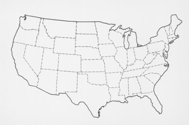
The United States of America is a relatively simple shape to draw. The key is keeping the shape proportionate. Before you start, consult a picture or map of the United States. Some may find it useful to keep this picture nearby, to reference the specific shapes of certain areas of the country. To accurately depict the United States, only a few steps are necessary.
Step 1
Draw the slightly curved northern border first. Outline the great lakes, then add the northeastern border slightly above the rest of the northern border.
Video of the Day
Step 2
Draw the right side of your image, outlining the Eastern Seaboard. Stop when you come to the northeastern tip of Florida.
Step 3
Draw the West Coast down the left side of your image. As you curve around to the southwestern border of Texas, line up your West Coast with the line you started for the East Coast. The West Coast should be about as tall as the northeastern coastal states.
Step 4
Continue the East Coast, then the Southern states until you come to the side of Texas. Sketch in the outline of Texas on the bottom edge to complete the outline.
Step 5
Add state border lines if you choose. Work from your picture of the United States to accurately mark them in. Go over your pencil lines in pen or with a marker, then erase your pencil lines. Add color or sketch in topographical details.
Video of the Day