
Watch a weather report on television and you'll likely hear the meteorologist say something about an approaching low pressure system, followed up by a prediction for a chance of rain in your area. That those two factors appear together is not a coincidence, however, many people don’t know why this happens with regularity. There's a good explanation. As you learn about how low pressure systems affect weather, you may be able to forecast the weather and approaching rain on your own by watching a barometer.
Rising Air Condenses
High and low pressure readings are an indicator of how much weight the atmosphere is pushing down on a particular area. When the pressure is low, the air is free to rise into the atmosphere where it cools and condenses. This condensation forms clouds made of water droplets and ice crystals around dust particles in the sky. Eventually the water vapor in the clouds condenses and falls as rain. Without low pressure, much of the air and the water vapor within it wouldn’t reach a high enough altitude to condense, so it wouldn't rain. This is why when you see areas of low pressure, rain often follows.
A Low Pressure System Brings Steady Rain
Rain comes down in varying intensities, so long, steady rain isn't always what you'll see. When a long, steady rain does happen, it's because of the location of the low pressure system in relation to a warm front. In the United States it's common to see a low pressure system produce long, steady rain or snow just north of a warm front. Warm, moist air enters the area of low pressure and is pulled up and over the mass of cool air ahead of the warm front. This results in longer, steadier periods of rain or snow.
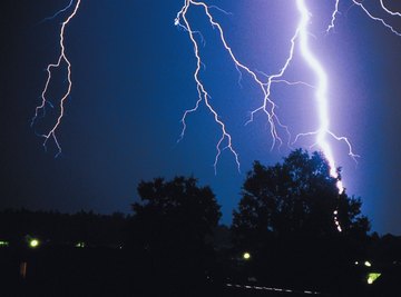
Low Pressure and High Temperature Equal Thunderstorms
When a low pressure system is positioned just ahead of a cold front, the warmer, less stable air ahead of the front has the potential to become a thunderstorm inside the counter-clockwise rotating low pressure area. This is the situation that produces the most severe thunderstorms and the shorter, heavier downpours that are seen commonly in the spring and summer in many areas. The lower the pressure, the higher the air is able to rise and form storm clouds. And typically, the higher the clouds the more severe the thunderstorm potential is.
Causes of Low Pressure
The sun is the main cause of the differences in pressure around the world. Because of the rotation and shape of the earth and the rising and setting of the sun, different parts of the world are subjected to a variety of temperatures at any given time. A difference in temperature affects the amount of pressure in that area, too.
The atmosphere constantly adjusts to try and equalize pressure across the planet, often without success. As that cycle of fluctuating pressure is powered by variations in temperature, the areas of high and low pressure move around. The variance can also be perpetuated by powerful weather systems. For example, in large rain or snow systems, the low pressure system is lowered further because of the warming that takes place as a result of the presence of water vapor heated by the sun.
References
About the Author
Lee Morgan is a fiction writer and journalist. His writing has appeared for more than 15 years in many news publications including the "Tennesseean," the "Tampa Tribune," "West Hawaii Today," the "Honolulu Star Bulletin" and the "Dickson Herald," where he was sports editor. He holds a Bachelor of Science in mass communications from Middle Tennessee State University.
Photo Credits
Jupiterimages/Photos.com/Getty Images