The period from August through mid-September marks the height of a six-month hurricane season in the North Atlantic. When hurricanes occur, most ships disperse to safer locations, leaving a void in data-collecting ability for meteorologists. That's when NASA, the National Oceanic and Atmospheric Administration (NOAA) and the National Weather Service (NWS) step in to gather information. But to monitor these storms and the winds that cause so much damage, these organizations need specialized tools.
Saffir-Simpson Scale
The Saffir-Simpson Hurricane Scale was developed as a tool for categorizing hurricanes according to sustained wind strength, measured for one minute, at approximately 10 meters (33 feet) above the water's surface. The categories consist of: Category One Hurricane: 74 to 95 mph sustained winds, which will deliver some damage. Category Two: 96 to 110 mph sustained winds, creating widespread damage. Category Three: 111 to 130 mph sustained winds, with overwhelming destruction. Category Four: 131 to 155 mph sustained winds, producing catastrophic destruction Category Five: Sustained winds 155 mph or greater, with catastrophic results
Ocean Temperature Measurement
Tropical Rainfall Measuring Mission (TRMM) microwave imagers and Advanced Microwave Scanning Radiometers (AMSR-E) measure temperatures of ocean surface waters, which determine the direction a hurricane will travel and potential hurricane intensity. A floating buoy dropped from an airplane sends out a spool of wire to determine the water temperature and radios it back to the plane.
Satellites
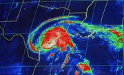
Scientist Vernon Dvorak developed a method for estimating hurricane strength by comparing satellite images with physical characteristics of the hurricane. This has become the basis for hurricane forecasting models used by meteorologists. NASA satellites collect hurricane data from space combined with computer-based climate mock-ups of sea surface temperatures, rain, wind and wave height.
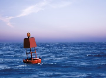
Buoys
Buoys remain the last manmade structure in the waters in and near hurricanes, and because they don't travel, buoys are suitable for the attachment of weather measuring instrumentation. Buoys can measure wind and air pressure, water and air temperatures as well as wind direction with anemometers, and they can measure sustained wind speeds in one-minute increments.
Reconnaissance Aircraft
Hurricane reconnaissance airplanes fly into hurricanes to measure wind speeds and barometric pressure and visually inspect the ocean surface. Planes travel at altitudes of approximately 10,000 feet and calculate wind measured at 10 meters above sea level based on measurements at 10,000 feet. Dropsondes descend from the plane with a pint-sized parachute to measure wind speed, providing approximate wind readings closer to the water surface, but they only gather localized snapshots rather than sustained wind speed information.
References
About the Author
Joan Whetzel has been writing professionally since 1998. She has written juvenile nonfiction, movie and television scripts and adult nonfiction. Her juvenile nonfiction has appeared in such magazines as "Tech Directions," "Connect" and "Class Act." She was part of the production team that produced the documentary "Fuel for Thought" on Houston PBS. She has also written articles for Katy Magazine Online.