
Recognizing simple atmospheric changes can provide you with a great deal of information about the weather to come. This knowledge can help you plan for a wonderful outdoor activity, or give you time to adequately prepare for impending bad weather. A drop in air pressure and temperature is a tell-tale sign of an approaching cold front. These fronts are responsible for producing severe weather, such as intense rain, hail, damaging wind gusts, lightning and even tornadoes.
Cold Front Basics
Cold fronts represent the leading edge of a cold air mass that is replacing an area of warmer air. Because the colder air is denser than the warmer air, it plows under the warmer air, forcing it to rapidly rise. This uplift causes it to cool, forcing the release of moisture, called condensation. It is this condensation that produces clouds with vertical development. Cold fronts are primarily associated with low-pressure systems. They typically form to the south of the pressure center, extending for long distances. They circulate the cyclone in a counter-clockwise motion, generally moving in an east-northeasterly direction.
Cold Front Pressure Effects
As a cold front approaches, the atmospheric pressure will steadily drop, signaling the approach of the low pressure system. As the front passes over your location, the pressure will stabilize. As the front and low pressure system continue to move away, the pressure will begin to gradually climb again.
Cold Front Temperature Effects
Ahead of a cold front lies an area of warm, moist air. As the front approaches, a gradual drop in temperatures will begin to be felt. The passing of the front will be signaled by a sudden, steep drop in temperatures. As the front continues to move away, temperatures will continue to gradual decrease until they bottom out.
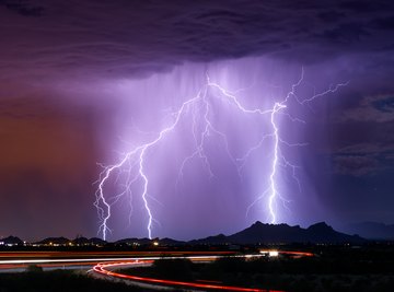
Cold Front Weather Effects
As a cold front approaches, the first signal in the skies will be the formation of wispy cirrus clouds. As the front nears, these clouds will give way to the development of puffy cumulus clouds. As the warm air is forced upward, these clouds will begin to show vertical development, known as towering cumulus clouds. Finally, mature thunderstorms will form, known as cumulonimbus clouds. These storms can be isolated or part of squall lines located along, or ahead of, the frontal boundary. These storms are responsible for severe weather and can pose a hazard to life and property.
Duration of Cold Front Effects
Because they are denser than the warmer air they are replacing, cold fronts have more mass and momentum. This allows them to plow through the warmer air, moving much faster than warm fronts. As a result, the weather associated with cold fronts, while severe in nature, is relatively short-lived for a given location. Typically, storm cells or squall lines will pass overhead within 30 minutes to an hour. Behind the front, you will encounter clearing skies and cooler temperatures.
References
About the Author
Doug Bennett has been researching and writing nonfiction works for more than 20 years. His books have been distributed worldwide and his articles have been featured in numerous websites, newspapers and regional publications. Bennett's background includes experience in law enforcement, the military, sound reinforcement and vehicle repair/maintenance.