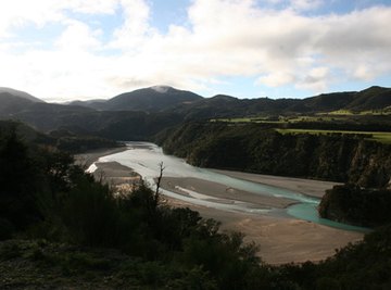
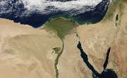
A flood plain is a type of geological feature that results when a river periodically overflows its banks due to rainfall, snow melt, or other factors. Floodplains are initially formed due to the meandering course of a river that gradually develops new geographical structure. Floodplains were critical to the survival of human civilization in antiquity because of their role in promoting agriculture, such as the annual flooding of the Nile River delta in Egypt. Flood plains contain other geological features such as oxbow lakes, point bars and natural levees due to the erosion and deposition of alluvium, or sediment.
Formation of Floodplains
Floodplains naturally develop as the result of erosion and aggradation (which is the deposition of material by the river). These processes happen as the natural meandering and carrying of sediment by the river changes the landscape. Rivers meander as they begin to curve and twist in different directions. This can change the ways in which the river erodes and levels the surrounding landscape. Floodplains are simply large areas surrounding a waterway that often flood and then become submerged during seasonal high water or floods.
As the river meanders and changes, it also brings alluvium and earth material (silt, gravel, etc.) which it deposits on the river bed and banks through the process of aggradation. The accumulation of this sediment additionally continues to change the surrounding floodway.
The major geographic makeup of a river floodplain can be described by the main water source, called the floodway, and the surrounding flat land called the flood fringe. The floodway is simply the primary river or waterway, and the flood fringe is where floodwaters intrude during times of higher water levels.
Because of the periodic change and fluctuation in floodplain regions, the surrounding land often supports high biodiversity and diverse ecological systems. These riparian areas support a wide range of wildlife habitats, landforms, and riverine flora and fauna.
Geographical Features of Rivers and Floodplains
Oxbow Lakes
An oxbow lake is a crescent-shaped lake that results from the meandering course of a river along a floodplain. According to Enchanted Gardens Wetlands Restoration, the defining factor in the formation of an oxbow lake is erosion. Water flows more quickly on the inside edge of a bend than it does on the outside edge, eroding the two adjacent banks on either end of the meander over time and diverting the water flow along a straighter path. The cut-off portion of the river becomes an oxbow lake. Oxbow lakes eventually become wetland due to the deposit of sediment and lack of water flow.
Point Bars
Point bars consist of alluvium that has been swept or rolled into place by secondary water flow at the bottom of the river. According to MIT, secondary water flow results from a pressure differential created by differing velocities of primary water flow along a curved path. The pressure causes gravel and silt to roll or be swept into place, creating a gentle slope that matches the riverbank's elevation.
Levees
Natural levees form when a river periodically floods its bank and deposits coarse alluvium such as gravel onto the banks in progressively higher stages when the river spreads and slows down its flow. If the river is not flooding, alluvial deposits can settle on the riverbed, thus raising the river level. Natural levees act as raised boundaries against rising water levels.
Groundwater and Aquifers
Floodplains provide great opportunity for water to permeate into the ground and create freshwater aquifers to store large amounts of water underground. As alluvial deposits accumulate, they create a natural system for water to permeate the gravel, silt, and clay and settle beneath in large underground pockets of water. These aquifers often have very high water quality because the process of seeping through these layers of sediment actually creates a natural filtration system.
Floodplain Management
The hydrological study of geography becomes increasingly important to human settlements and anthropomorphic interaction with ecosystems as humans continue to expand and settle in new regions. The continued expansion is also coupled with the process of climate change which brings increased severe weather events – and often higher rates of flooding.
When we study watershed regions (a large region where all water drains to the same river channel), it is crucial to look at the flood risk and inundation of the flowing water in these areas. There are many natural floodplains that are very healthy for the surrounding ecosystem, as they provide seasonal nutrients and rejuvenation for the flood fringe and beyond. However, as human activity continues to intrude into these open spaces, awareness of floodplains is crucial to preventing serious disaster.
Many cities and settlements are already established within flood plains. New Orleans, LA is a key example of a large city that is settled in a high risk flood area. There is periodic flooding caused by seasonal weather and precipitation, and this is reasonably addressed with flood control practices – such as artificial levees and flood walls. However, in the event of serious flood events (brought upon by excess precipitation, hurricanes, or other inclement weather) it is very easy for the Mississippi River and the ocean to overflow and cause massive damage. This was seen with hurricane Katrina in 2005, when the resulting damages required a massive response from FEMA and other disaster agencies; it caused many casualties and resulted in billions of damages.
As climate change continues to increase the risk of these serious weather events, it becomes increasingly important to observe and responsibly manage floodplains – especially in regions with large settlements.
References
About the Author
Michael Smathers studies history at the University of West Georgia. He has written freelance online for three years, and has been a Demand Studios writer since April 2009. Michael has written content on health, fitness, the physical sciences and martial arts. He has also written product reviews and help articles for video games on BrightHub, and martial arts-related articles on Associated Content.
Photo Credits
Floodplain image by Bailey from Fotolia.com