
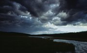
The physical face of the Earth and the lower atmosphere interact in many complex ways. Just as climate can impact topography--with glaciers created during an ice age, for example, eroding vast swaths of terrain--so too can topography engage with weather patterns. This is particularly easy to discern in mountainous tracts, where prevailing weather systems must deal with vertical swells.
Orographic Lifting

One of the prime examples of landform influences on weather patterns concerns orographic lifting--the process by which mountains shunt air upwards as atmospheric systems encounter them. If the mountains are high, they may force air high enough to cool and reach its saturation point, with water vapor condensing to form clouds and possibly precipitation. This very phenomenon explains the immense winter precipitation of the coastal ranges of the Pacific Northwest, including the west slope of the Cascades; these formidable highlands stand in close proximity to the Pacific Ocean, which sends moisture-laden systems their way.
Rainshadow Effect

Orographic lifting can wring out moisture from weather systems so that the lee or downwind side of the mountains experience a much drier climate. In the Cascade Range example, the western slopes of the range create heavy cloud cover and high precipitation. The air masses then descend and warm over the eastern flanks of the Cascades, far drier. This explains the semi-arid steppe and scattered true desert found in eastern Washington and Oregon. The same condition occurs just south with the Sierra Nevada and the deserts of the Great Basin eastward.
Landform Breezes

A familiar affect of landforms on weather is experienced in mountainous or hilly country: the daily rhythms of “mountain and valley breezes.” These shifting wind patterns derive from differential rates of heating and cooling between slope crests and drainage bottoms. During the day, high slopes heat up more quickly than the innards of valleys, creating low pressure; this draws breezes up from the valley (the valley breeze), as air moves from areas of high to low pressure. At night, the opposite effect happens: The uplands cool more quickly, amassing high pressure, so breezes begin spilling down into the valley bottom (the mountain breeze). The extremities of the topographic heat disparities mean that the valley breeze is usually strongest around noon, the mountain breeze immediately prior to sunrise.
Wind Funnels

Topographic uplifts can also affect wind concentration and strength. A mountain chain often separates two regions of different atmospheric pressures; winds “want” to flow as directly as possible from the high-pressure zone to the low-pressure one. Therefore any mountain passes or gaps will see high winds at such times. The Columbia River creates a massive example of such a gap in the Cascade Range on the border of Washington and Oregon--a sea-level passage through those volcanic ramparts often funneling high-speed winds. Many gap winds around the world are so powerful and reliable that they have been named: the “levanter,” for example, through the Straits of Gibraltar between Spain and Morocco; or the “tehuantepecer” of Central America.
References
- Univ. of Illinois WW2010: Lifting Due to Topography
- "Meteorology: Understanding the Atmosphere"; S.A. Ackerman, J.A. Knox; 2003
Resources
About the Author
Ethan Shaw is an independent naturalist and freelance outdoors/nature writer based in Oregon. He holds a B.S. in Wildlife Ecology and a graduate certificate in G.I.S. from the University of Wisconsin-Madison. His primary interests from both a fieldwork and writing perspective include landscape ecology, geomorphology, the classification of ecosystems, biogeography, wildlife/habitat relationships, and historical ecology. He’s written for a variety of outlets, including Earth Touch News, RootsRated, Backpacker, Terrain.org, and Atlas Obscura, and is presently working on a field guide.