The American Southwest is defined differently by different sources on the basis of culture, not just geography. Many agree that the region is made up of all of the territory acceded in the Mexican Cession following the war against Mexico in the 19th century: California, Utah, Nevada, Arizona, New Mexico and Texas, with parts of Oklahoma and Colorado. This climate is typically hot, elevated and dry, so the major water bodies tend to be rivers, rather than lakes.
Great Salt Lake
Utah's Great Salt Lake is the largest saline lake in the Western Hemisphere. It is the remnant of an ancient lake known as Lake Bonneville, which used to be as large as Lake Michigan until a cataclysmic flood during the most recent Ice Age reduced it to near its current size.
Colorado River
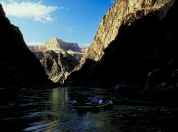
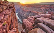
The Colorado River is the most well known river in the United States other than the Mississippi. It originates in Colorado, winding through Utah, Nevada, Arizona, California and the Mexican states of Baja California and Sonora before terminating in the Gulf of California. Most famously, it travels through the Grand Canyon and the Hoover Dam. Indeed, 17 million years ago, the Colorado River and its tributaries slowly began carving out the Grand Canyon.
Rio Grande
Also known as the Rio Bravo to Mexicans, this river famously comprises Texas' entire western border, physically separating it from the Mexican states Chihuahua, Coahuila, Tamaulipas and Nuevo Leon. It travels from Colorado, through New Mexico, down the length of Texas and terminates in the Gulf of Mexico. It is the fourth longest river in the United States.
Gulf of Mexico
The Gulf of Mexico is an ocean basin, containing within it the entire eastern coast of Mexico, Texas, the Gulf States, and part of Cuba. Scientists believe the Gulf of Mexico was formed during the Late Triassic geological period as a result of continental rifting of the supercontinent that comprised the entire landmass on Earth. It is the ninth largest body of water in the world.
References
About the Author
Based in the New York City Metro area, James Woudon began writing in 1999. He is a former editor of the college publication, "John Doe Comics." Woudon holds a Bachelor of Arts in communications from Rutgers University.
Photo Credits
Jupiterimages/Photos.com/Getty Images