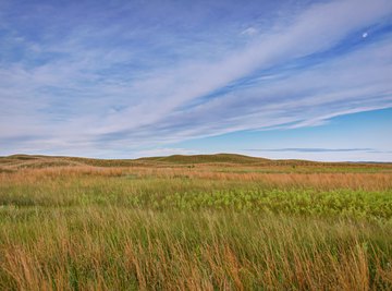
The Great Plains of the United States lie between Canada and Mexico to the north and south and between the Rocky Mountains and the Central Lowland to the west and east. The Great Plains slope from 7,000 feet above sea level in the Rocky Mountains down to about 2,000 feet on the west edge of the Central Lowland region. The Great Plains form the western portion of a larger geologic region called the Interior Plains Province. This semi-arid, nearly treeless plateau covered with shortgrass may appear relatively flat and featureless, but appearances can be very deceiving.
Plain Landform
While the plain landform can form in several different ways, a plain definition (no pun intended) from the National Geographic Society states that a plain is "a broad area of relatively flat land." Plains cover over a third of the Earth's land surface and exist on every continent, at the bottom of oceans and even on other planets. Examples of plains include grasslands like the prairies of North America, steppes of Asia and eastern Europe, and savannahs of tropical Africa, South America, southern North America and Australia. Mexico's Tabasco Plain is forested while parts of the Sahara Desert are also plains.
Formation of Plains
These flat plains almost all result, directly or indirectly, from erosion. As mountains and hills erode, gravity combined with water and ice carry the sediments downhill, depositing layer after layer to form plains. Rivers form plains through related processes. As rivers erode rock and soil, they smooth and flatten the land they pass through. As rivers flood, they deposit the sediments they carry, layer upon layer, to form flood plains. When rivers carry their sediment load into the ocean, they deposit the sediments as they slowly merge into the sea. When the river sediments build up enough, they can rise above sea level. Combined with runoff from hills and mountains, these sediments form coastal plains.
Abyssal plains form on the ocean floor when sediments and ooze settle and accumulate on the bottom of the ocean over long periods of time. Extensive lava flows also may form plains, like the Columbia Plateau. Plateaus are flat areas elevated above the surrounding area. The largest plateau in the world is the Tibetan Plateau in central Asia.
Formation of the Great Plains
The Great Plains began over a billion years ago, during the Precambrian Era, when several small continents joined together to form the core of what would become North America. Despite the subsequent mountain-building along the east and west edges of the developing continent, the central interior plain stayed relatively flat and stable through the Paleozoic and Mesozoic Eras. Erosion from the mountains to the east and west of the plain carried sediments down into the plain.
Most of that time the plain remained above sea level, but for a time during the Jurassic Period of the Mesozoic Era, the shallow Sundance Sea covered a large portion of the interior plain. Rising sea levels during the Cretaceous Period near the end of the Mesozoic Era again flooded the interior plain. Besides the continued deposition of sediments, many dinosaur bones were washed into or sank into the sediments of these shallow inland seas. The fossils found in these sedimentary rocks provide glimpses into the time when dinosaurs and other animals roamed across the Great Plains.
After the end of the Mesozoic, the sea retreated again, and erosion from the east and west, especially the Rocky Mountains to the west, continued to provide sediments to the Great Plains. From the Eocene on, sediments continued to deposit across the northern interior plains. Between 20 and 30 million years ago, the deposition extended from the northern Great Plains south as far as modern Texas. 10 million years of deposition eventually developed into the Ogallala Formation, which now serves as a major aquifer for the region.
During the Pleistocene Epoch, great ice sheets developed and covered much of North America. The ice smoothed and flattened the eastern portion of the interior plain, mostly between the Missouri and Ohio Rivers. The eastern edge of the Great Plains is located roughly along this glacially smoothed area.
References
- U.S. Geological Survey: Geologic Provinces of the United States – Interior Plain Province
- U.S. Geological Survey: The Geologic Story of the Great Plains
- U.S. Geological Survey: Geological Survey Bulletin 1493 – What Is the Great Plains?
- Encyclopedia.com: Great Plains
- National Geographic Society: Plain
- National Geographic Society: Plateau
About the Author
Karen earned her Bachelor of Science in geology. She worked as a geologist for ten years before returning to school to earn her multiple subject teaching credential. Karen taught middle school science for over two decades, earning her Master of Arts in Science Education (emphasis in 5-12 geosciences) along the way. Karen now designs and teaches science and STEAM classes.