Your house might be on the Internet and you may not know it. Google has a map site that displays satellite images of locations around the world. Even though satellites snap pictures of these locations from space, you can still zoom in on them online at Google Maps. If you'd like to take an even closer look at your house or an address you can activate Street View and see your house or address from ground level.
Use Google
Video of the Day
Step 1
Launch your browser and navigate to the Google Maps Web page (link in Resources). Type the address of a house or location you'd like to see in the search box at the top of the page. Include the address's city and state. As you type, Google Maps displays a drop-down box that contains a list of locations that match what you type.
Video of the Day
Step 2
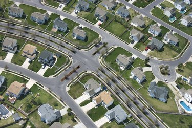
Click the blue "Search" button next to the "Search" box. Google displays a map of the address and places a red marker there. Click the "Satellite" button in the page's upper right corner and wait as Google Maps shifts to satellite view. When it does, you can see an overhead view of the address.
Step 3
Double-click the red marker. The virtual camera will zoom in a little closer on the location. Continue double-clicking until you reach the zoom level you desire. If you double-click an area adjacent to the marker, the camera zooms in on that location. As you zoom closer, you can see the tops of houses. Click the vertical slider on the map's left side and drag it up and down if you'd like to zoom in and zoom out without double-clicking. You may find this method better when you want to change the zoom level quickly.
Step 4
Click any area in the image, hold down your mouse button and drag your mouse to change your view of the scene. You might want to do this if the house you're looking for is nearby but not quite in the scene.
Step 5
Find the orange "Man" icon near the map's left side. Click and drag the icon onto the red marker. Doing this activates Street View, which shows a photograph of the location from ground level as seen from a camera lens.
Step 6
Click inside the picture and then press your left and right arrow keys to rotate the view left and right. Press your up and down arrow keys to move forward and backwards through the scene. Continue pressing these keys until you obtain the view of the location that you like.
Use Yahoo
Step 1
Navigate to the Yahoo Maps website and type the location of your house in the "Search For (Location, Address, ZIP Code)" text box.
Step 2
Click "Get Location." Yahoo Maps searches for the location and displays a red marker over it on the map.
Step 3
Move your mouse over the "Map" icon and select "Satellite" to view a satellite image of the location. A vertical scale appears on the map's right side. Click the scale's slider, hold on your left mouse button and drag the slider up and down to zoom in and out of the satellite view. You can also click the "+" button at the top of the scale and the "-" button at the bottom of the scale to perform the same tasks.
Use Bing
Step 1
Visit the Bing Maps website and type your house's location in the text box at the top of the page.
Step 2
Click the "Search" icon, shaped like a magnifying glass, to view a map that contains the location you entered. Bing places a blue icon with the letter and it over the location.
Step 3
Click the "Bird's Eye" button to switch to satellite view. Click and drag the map to get a better of the location if needed.
Step 4
Click the "+" button to zoom in on the location; click the "-" button to zoom out. When you move your mouse over one of those buttons, a vertical scale appears between the two buttons. This scale as a slider you can click and drag up and down to zoom in and out of the satellite view.