

A magnetic compass needle will always point to magnetic north. To calibrate a compass properly, you must understand that magnetic north and true north are not the same directional value. In fact, magnetic north is approximately 1,000 miles away from the true North Pole, and the distance between these two points can change significantly based on your specific geographic location when using a compass. This phenomenon is referred to as "magnetic declination" and requires you to adjust your compass while using a map that features both magnetic and true north directions. Your adjustments will vary based on your specific geographic location.
Items you will need
Magnetic compass
USGS topographical map
Step 1
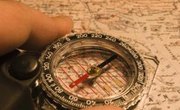
Lay a USGS topographical map out flat and place your compass on the map. Place the compass near to the directional indicators marking true north and magnetic north.
Step 2
Line up with the true north arrow indicator on the map by placing the heading arrow on the compass in sequence with the true north line.
Step 3
Rotate the compass housing dial until it is lined up with the magnetic north indicator on the map.
Step 4
Keep the compass in place and then rotate the map until the compass needle is pointing north in sequence with the magnetic north line. The compass and map will now be calibrated and aligned with a true north direction.
Tips
- USGS maps are calibrated to suit the location of their use. The true north and magnetic north lines will fluctuate based on the geographic location where the map will be used.
References
Tips
- USGS maps are calibrated to suit the location of their use. The true north and magnetic north lines will fluctuate based on the geographic location where the map will be used.