
Have you ever consulted a map produced by the U.S. Geological Survey or similar geography-assessing body and wondered what all of those wavy lines and related markings were for? Maps that include contour lines, are no longer limited to printed documents. Contour maps offer a deceptively high amount of information when analyzed skillfully, and can be accessed on command using online mapping sites and applications.
Contour lines are spaced by contour intervals and represent areas on land that lie the same distance above sea level, taken to be zero feet (0') by convention. That means that if you were to precisely follow the path shown by a contour line – which is often but not always a closed loop – your elevation would not change at all even as the scenery around you likely varied considerably during your trip.
Graphically, contour lines offer a sense of the topography, or hilliness, of the area the map depicts. Since each contour line represents a given elevation above sea level (also called altitude or simply elevation), mapmakers must choose how many representative elevation lines to employ without either crowding out other details by using too many such lines or failing to to supply enough basic elevation information by using too few.
How Are Elevation Data Useful?
If you use Google Maps or another online service to plan a driving trip, you are most likely concerned with the total distance from start to finish and with the quality of the available roads. However, if you are hiking that same distance, you might be more interested in the topography of the land you will cover. It is probably not just because of the views that might be offered, but because you want to know how tall the hills are that you will have to climb.
- Elevation data are usually given in feet (ft) in the United States and meters (m) elsewhere, with 1 m = 3.281 ft. For example, 5,280' is the altitude of downtown Denver, Colorado, USA.
Elevation influences a number of interrelated local factors, including climate and the level of oxygen pressure in the air, both of which can determine whether a person wishes to live in, or can even safely visit, a given location. Some people experience a phenomenon called altitude sickness at certain elevations and would be affected if traveling to, for example, a ski area in the Rocky Mountains, where altitudes routinely top 10,000'.
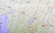
The Topographical Map
Most maps represent three-dimensional land in a way that disposes of up and down and focuses only on traveling "horizontally" (some combination of north, east, south and west, or 0 to 360 degrees on a compass). Topographical maps introduce the third, vertical dimension by providing a pictorial representation of the hilliness or flatness of the terrain.
Most topographical maps show details in addition to contour lines and elevation data that are absent on traditional street maps. For example, since many of these are aimed specifically at hikers, runners and other purposeful explorers rather than motorists, certain features such as foot and bike trails, relatively small streams and brooks, and swampland are specifically noted wherever possible.
Contour lines represent the main feature of "topo maps" that are not part of the natural landscape; clearly, you won't see lines painted on the ground when you take to the areas shown. At the same time, contour lines provide an undeniably accurate and distinct "feel" about the associated terrain, a feeling that frequent users such as orienteering competitors report growing stronger over time.
Contour Lines in Detail
Contour lines have a number of features in common regardless of the land shown on a given map. Some of these are evident at a glance, but you may not appreciate them or their importance without a formal explanation.
Contour lines have the following universal characteristics:
- They never cross each other, divide or split.
- Closely spaced contour lines represent steeper slopes, while lines that are spaced far apart depict gentler inclines and declines.
- They create upward trends on the sides of valleys and form a V- or a U-shape at stream crossings.
A moment of thought makes it easy to reckon with this information. Since distinct contour lines by definition represent different elevations, having them cross would be physically impossible for the same essential reason 2 never equals 3. Also, you would expect steeper slopes to have contour lines closer together, since every step you take north, east, south or west in real space under these conditions means climbing or descending a greater amount.
- Occasionally, you will see a series of concentric contour lines enclosing each other that have cross-hatching marks. This signifies that the elevation is decreasing toward the central point of this region rather than increasing, making the terrain feature a depression rather than a hill. Can you propose a reason that these are rarely needed?
What Is a Contour Interval?
The best way to familiarize yourself with the concept of contour lines and contour intervals is to study the legend of the map, which tells you how far apart in vertical feet or meters adjacent contour lines are. This might be a number convenient to both math (such as 10 meters, or 20 or 40 feet) and the reality of the local terrain.
If you look at the map itself, you'll see that some contour lines are darker than others and are often labeled with numbers corresponding to the elevation in feet or meters. This allows you to find a reference elevation pertaining to a spot on the map close to or within the area you'll explore. After all, knowing how steep or flat a place is gives only part of the story; you probably want to now how "high" or "low" you are in absolute terms, too.
Looking at contour lines helps you picture what a terrain feature would look like on the ground from a given distance. For example, if a map depicts a long, oblong hill with contour lines converging to a point far from the center, you would see this from the ground as a hill with a peak dropping sharply on one side and gradually on the other side.
Index Contours
The aforementioned dark, labeled lines are called index contours, because their purpose is to tell you an exact elevation at a precise point in space, allowing you to work outward, and thus upward or downward, from there. The associated elevations usually end in "0" for convenience, although on metric maps they sometimes end in "5."
For example, a topographical map of an area near Denver might have index contours of 5,000', 5,100' and so on with a contour interval of 20 feet. This means that there would be five "spaces," and four non-index contour lines, between each index contour.
Often, index points are given along with index contours. For example, the precise elevation of a mountain peak is given even when it does not correspond with a contour line. Other points of interest, such as national parks, are often similarly labeled.
- The reason you rarely see depressions on topo maps is fairly simple: These usually fill up with water and are called ponds and lakes! Only when water is somehow unable to find its way into such an area, such as in conditions of very low annual rainfall, do hatched contour lines usually appear.
References
About the Author
Kevin Beck holds a bachelor's degree in physics with minors in math and chemistry from the University of Vermont. Formerly with ScienceBlogs.com and the editor of "Run Strong," he has written for Runner's World, Men's Fitness, Competitor, and a variety of other publications. More about Kevin and links to his professional work can be found at www.kemibe.com.