
Landforms are physical features of the earth that have formed without influence from humans. Although the Midwestern region of the United States is generally flat, it contains some major landforms that vary in elevation, such as rolling hills, rising mountains and descending valleys. Flatter landforms include plains, plateaus and large lakes. The Midwest is made up of Ohio, Michigan, Indiana, Illinois, Iowa, Kansas, Nebraska, Missouri, Wisconsin, North and South Dakota, and Minnesota.
Plains and Plateaus
The Great Plains stretch across the Midwest from Missouri and Nebraska, where there are relatively flat grasslands with treeless areas and fertile soil suited for farming, northward to the hillier country of the Dakotas. Plateaus are landforms similar to plains in that they are flat, but they are found at higher elevations than plains and are usually surrounded by steep slopes. Two plateaus in the Midwest are the Appalachian Plateau in eastern Ohio and the Ozark Plateau in southern Missouri and portions of Kansas and Illinois.
Mountains and Hills
The Ozark Mountains are a heavily forested, highland area that traverse the Midwest primarily through Missouri and portions of southern Illinois and southeastern Kansas. Hills are formed from the deposition of erosion or are the remains of a weathered mountains. The Black Hills in western South Dakota formed from rock being lifted upward, then wind and water eroding away the summit of a mountain. At 1,772 feet, the highest peak in the Midwest is Missouri's Taum Sauk Mountain.
Lakes and Rivers
Rivers and lakes are not always considered landforms, but they are naturally occurring physical features of the earth. The Great Lakes, consisting of lakes Erie, Superior, Huron, Michigan and Ontario, border the states of Ohio, Michigan, Indiana, Illinois and Wisconsin and make up 20% of the world's fresh water. Major rivers found in the Midwest are: the Mississippi, which runs from northwest Minnesota to the Gulf of Mexico; the Ohio, which forms the southern borders of Ohio, Indiana and Illinois; and the Missouri, which is the longest river in the United States, stretching across the Midwest into the western states.
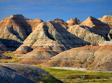
Valleys and Ravines
Valleys are natural depressions between hills or mountains formed over long periods of time from water or ice erosion. They have a low elevation and usually slope down toward a body of water. Three major valleys in the Midwest are the Ohio, Missouri and Mississippi valleys. The Badlands, located in western South Dakota, although also formed from water and wind eroding sedimentary rock, differ from the river valleys in that they are compromised of a series of narrow valleys, or ravines, dotted with buttes and ridges.
References
- New World Encyclopedia: Midwestern United States
- World Atlas: Landforms
- World Atlas: Geography
- Ohio History Connection: Appalachian Plateaus
- Encyclopedia Britannica: Black Hills
- Northern State University: South Dakota Badlands
- Michigan Department of Environmental Quality: Great Lakes Map
- World Atlas: Significant Rivers of the Continental USA
- Encyclopedia Britannica: Ozark Mountains
About the Author
Diana K. Williams is a certified Master Gardener, has more than a decade of experience as an environmental scientist, and holds a Bachelor of Science degree in biology and environmental studies from the Ohio Northern University. Williams is a winner of Writer’s Digest Magazine's annual writing competition.