
You can use a variety of tools to determine the direction of the wind. In a pinch, you can simply put your wetted finger in the air to feel the wind’s direction, but if you need a more accurate reading, try a windsock or a pinwheel. These and other instruments serve as useful aids in determining weather patterns, or simply measuring the current conditions.
Windsocks: Elegantly Simple
Windsocks are very basic devices that measure wind direction and provide a rough idea of the wind's intensity. They comprise a tubular piece of fabric or thin, flexible fabric attached to a pole. In windless conditions, the fabric hangs vertically from the attached pole. When wind begins to blow, it fills the windsock and causes the sides to expand away from each other. This results in the windsock's rounded, cylindrical appearance and also causes the windsock to rise up to a horizontal position. Either the pole or the harness attached to the windsock can rotate when the wind changes direction, so the direction of the windsock will indicate that of the wind.
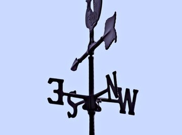
Weather Vanes: Tried & True
A weather vane works similarly to a wind sock. Instead of a tubular sock, this instrument consists of a horizontal pole placed atop a vertical one. The poles are joined together so that the horizontal pole can move independently of the structure's base. The horizontal pole has a flattened, vertical end that reacts to wind. This flattened end may be any broad, flat shape, such as the traditional rooster shape. When wind blows on the broad side of this end, it pushes it, causing the pole to rotate. When the pole has rotated to a position parallel to the wind's direction, the flattened end also sits parallel, and air moves by it on either side without having any further effect on the pole's position.
Pinwheels: Spinning in the Wind
A pinwheel is a windmill-style turbine that spins perpendicularly to the wind affecting it. Like wind socks and weather vanes, a pinwheel can be attached to a rotating base. This allows the pinwheel to change direction with the wind, and it will spin facing into the oncoming wind.
Anemometers: Measuring Wind Speed
While the above instruments indicate wind direction and provide some rough gauge of wind intensity, meteorologists use devices called anemometers to measure wind speed. Compared with the simple contraptions above, professional anemometers are often complex, computer-aided machines that measure and record wind patterns over time. More advanced anemometers perform valuable services in professional weather reporting and air traffic control. They are also used to monitor the ideal conditions for spacecraft launches, and as surveying tools when prospecting for wind-generated power stations.
References
Resources
About the Author
Rob Callahan lives in Minneapolis, where he covers style, culture and the arts for Vita.MN and "l'étoile Magazine." His work has earned awards in the fields of journalism, social media and the arts. Callahan graduated from Saint Cloud State University in 2001 with a Bachelor's degree in philosophy.
Photo Credits
weather vane image by Jeffrey Zalesny from Fotolia.com