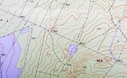
Contour maps provide an easy method of depicting the changes in elevation across an area. They let anyone visualize the shape of a landscape without having to fly overhead. Knowing a few simple rules can increase the amount of information gathered from any topographic map and help you interpret the features of any landscape.
Contour Lines Never Cross
Lines indicating elevation should never intersect on a topographic map, because each line represents a different elevation, so it is impossible to have two elevations at the same location.
Measuring Steepness
The closer together contour lines are, the steeper the slope of the hill. If the spacing between lines stays the same then the slope is constant. If the distance between lines changes, then the slope also changes.
Stream Flow Direction
When contour lines cross valleys, they will form a V shape. The V always points uphill. You can use this to determine which way water will flow across an area depicted on a topographic map.
Contours Close
Contour lines form irregular circles and do not end at a random point. Every contour line can be followed around back to where it started, although this may be beyond your map's borders.
Concentric Circles
Concentric circles represent hilltops and depressions. A depression or hollow where the elevation drops and is surrounded by higher terrain will be marked by closed irregular contours with hash marks on the line. The markings point inward from the edge and indicate that the area inside is lower. These areas will appear to have a crater or bowl shape.
Elevation Between Lines
The elevation between two contour lines is never higher than the value of the higher contour line. For example, between a contour line marking 500 feet and another marking 600 feet, there could not be a point where the elevation is 650 feet without additional contour lines.
References
About the Author
Marty Simmons started writing professional reports for the environmental consulting industry in 2008. His online instructional articles specialize in science and education. Simmons has a Bachelor of Arts in geology from Kent State University.
Photo Credits
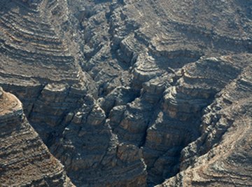
gorges pointe de musandam image by Emir OBOLAN from Fotolia.com