
Landforms are the physical features on the surface of the Earth. They are created by natural forces such as wind, water, erosion and tectonic plate movement. Landforms are typically categorized by their physical attributes of slope, stratification, soil type, elevation and orientation. The highest order of landforms are continents and ocean floors, but there are also sub-categories of major landforms familiar to most people.
Mountains

Mountains are perhaps the most spectacular and awe-inspiring of Earth's major landforms. Mountains can be formed by geologic forces such as volcanism and erosion, but geologists believe most mountains are formed as the result of heat and pressure beneath the Earth's crust which causes movement and uplift in the crust. This movement is called plate tectonics, which also causes earthquakes. Though we cannot see most of them, there are more mountains in the ocean than on land. Some islands are the tops of underwater mountains. The Hawaiian Islands are an example of mountains formed by volcanism.
Plateaus

A plateau is a large elevated or highland area with a relatively level or flat surface. The most well-known plateau in the world, the Tibetan Plateau, is located between mountain ranges, but others are higher than the surrounding land. Plateaus are formed by a variety of forces. Some are formed by upward folding of the Earth's crust, others by erosion of the surrounding land. The Columbia Plateau of the Northwestern United States was formed by repeated lava flows that covered thousands of square miles and built up the land over millions of years.
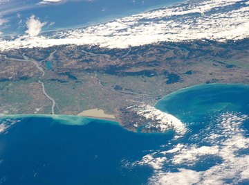
Plains

Plains are broad expanses of land with little change in elevation, and are usually lower than the land that surrounds them. Plains near the ocean are called coastal plains. Coastal plains gradually rise from the ocean to meet higher landforms such as plateaus and mountains. Some geologists consider coastal plains an elevated portion of the ocean floor. Inland plains are usually at higher elevations, such as the Great Plains of the United States. Many inland plains were formed by receding ice-age glaciers that left the land scoured and flat.
Glaciers and Ice Sheets
Glaciers are giant masses of ice that form in polar regions and high mountains and flow over land like slow rivers. Huge, ancient ice sheets cover all but the highest mountain peaks of Greenland and Antarctica. Together these two massive landforms hold more than 75 percent of the world's fresh water.
References
About the Author
Doug Donald has been writing online since 2004, covering business, relationships, health/exercise and food. His work has also been featured in the "Grosse Pointe News," magazines and corporate newsletters. Donald holds a Bachelor of Science in business and economics, as well as a Master of Business Administration from Central Michigan University.
Photo Credits
NASA/Getty Images News/Getty Images